

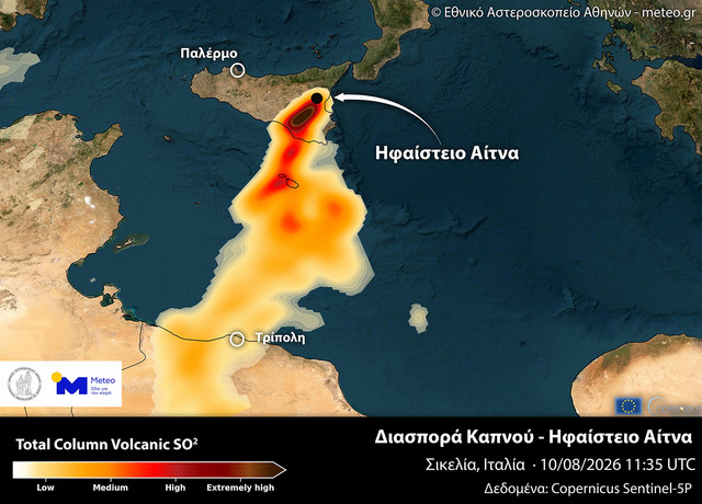
A volcanic cloud produced by renewed intense activity at Mount Etna in Sicily has reached the coast of North Africa, after crossing a large stretch of the Mediterranean Sea.
The cloud's path is shown on a satellite map created by the scientific team at the National Observatory of Athens/meteo.gr, using data from the European Sentinel-5P satellite under the Copernicus program. The National Observatory said Etna entered a new period of intense volcanic activity on Friday, August 7, with the activity peaking on Sunday, August 9, and Monday, August 10.
From Sicily to Tripoli
Scientists tracked concentrations of volcanic sulfur dioxide, known as SO2, across the entire atmospheric column. The map shows that, following prevailing winds, the cloud moved in a south to southwest direction, passed over the Mediterranean and reached the African coast and the area around Tripoli, the capital of Libya. The data relates to midday on Monday, August 10.
The map tracks sulfur dioxide rather than visible volcanic ash, a distinction the Observatory called significant because SO2 can travel long distances through the atmosphere and serves as a useful marker for following a volcanic cloud's path.
Why scientists track SO2
Sulfur dioxide is one of the main gases released during volcanic activity. The National Observatory of Athens said it was chosen for the mapping because it is emitted in large quantities by volcanoes and can be detected relatively easily by satellite instruments, allowing scientists to track both the extent and trajectory of a cloud while distinguishing it from other sources of atmospheric particles, such as dust. Sentinel-5P carries the TROPOMI instrument, designed to monitor atmospheric gases, which Copernicus uses to detect volcanic SO2 emissions and track their dispersal.
Etna activity continues
As the cloud traveled over the Mediterranean, activity at Etna itself remained intense. In its latest update on Monday evening, the Etna Observatory of Italy's National Institute of Geophysics and Volcanology (INGV) reported continuing lava flows from vents at altitudes of about 2,750 and 2,360 meters. The most advanced active lava flow had passed the Rocca delle Palombe area and descended to about 1,370 meters, according to INGV scientists observing on site.
Throughout Monday, intense explosive activity was recorded at the Voragine crater, producing large amounts of ash that fell on the volcano's southern side, while volcanic tremor remained at high levels. Etna, Europe's highest active volcano, is under continuous scientific monitoring, as its eruptions can affect areas beyond Sicily and, as the new satellite map shows, leave traces in the atmosphere hundreds of kilometers away.